42900 postal code
MexicoUpdated 2026-11-09Chapantongo Centro, HidalgoChapantongo5 digits
Postal code details
5 placesCode
42900
Place
Chapantongo Centro
Region
Hidalgo
County
Chapantongo
Coordinates
20.2866, -99.4155
Accuracy
3 / 6
Country
Mexico
Location
OpenStreetMap ↗


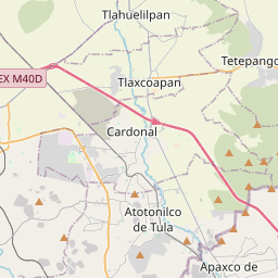
20.2866, -99.4155© OpenStreetMap
Ad slot · 300×250
Places under this code
5| Place | Region | County | Coordinates |
|---|---|---|---|
| Chapantongo Centro | Hidalgo | Chapantongo | 20.2866, -99.4155 |
| Guadalupe | Hidalgo | Chapantongo | 20.2942, -99.4289 |
| Piedra Grande | Hidalgo | Chapantongo | 20.2637, -99.4716 |
| Puerto Vallarta | Hidalgo | Chapantongo | 20.2928, -99.4039 |
| San Antonio | Hidalgo | Chapantongo | 20.2728, -99.4137 |
FAQ
Which city is 42900 in?
Chapantongo Centro, Hidalgo, Mexico.
What are the coordinates of 42900?
20.2866, -99.4155
Is 42900 used in other countries?
Yes, 2 other countries.
Updated 2026-11-09. Attribution in Data & license.