12200 postal code
MexicoUpdated 2026-11-09Nochtla, Distrito FederalMilpa Alta5 digits
Postal code details
4 placesCode
12200
Place
Nochtla
Region
Distrito Federal
County
Milpa Alta
Coordinates
19.2703, -99.0671
Accuracy
3 / 6
Country
Mexico
Location
OpenStreetMap ↗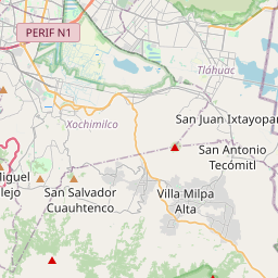


19.2703, -99.0671© OpenStreetMap
Ad slot · 300×250
Places under this code
4| Place | Region | County | Coordinates |
|---|---|---|---|
| Nochtla | Distrito Federal | Milpa Alta | 19.2703, -99.0671 |
| Ocotitla | Distrito Federal | Milpa Alta | 19.2034, -99.0217 |
| Panchimalco | Distrito Federal | Milpa Alta | 19.2703, -99.0671 |
| Tula | Distrito Federal | Milpa Alta | 19.1395, -99.0511 |
Nearby codes
All →Same code in other countries
10| Country | Place | Region |
|---|---|---|
| DE Germany | Bundesanstalt für Materialforschung und -prüfung | Land Berlin |
| ES Spain | Onda | Comunidad Valenciana |
| FR France | La Bastide-l'Évêque | Occitanie |
| KR South Korea | 화도읍 | 경기도 |
| LK Sri Lanka | Agalawatta | Western Province |
| MA Morocco | Tamesna | Rabat-Salé-Kénitra |
| MY Malaysia | Butterworth | Pulau Pinang |
| PE Peru | Ayla Pampa | Junín |
| PK Pakistan | Abbas Pur | Azad Jammu and Kashmir |
| PL Poland | Anuszewo | Warmia-Masuria |
FAQ
Which city is 12200 in?
Nochtla, Distrito Federal, Mexico.
What are the coordinates of 12200?
19.2703, -99.0671
Is 12200 used in other countries?
Yes, 10 other countries.
Updated 2026-11-09. Attribution in Data & license.