RM4 postal code
United KingdomUpdated 2026-11-09Abridge, EnglandEssexOutcode
Postal code details
9 placesCode
RM4
Place
Abridge
Region
England
County
Essex
Coordinates
51.6454, 0.1912
Accuracy
3 / 6
Country
United Kingdom
Location
OpenStreetMap ↗

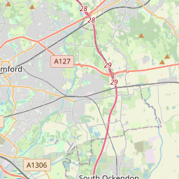

51.6454, 0.1912© OpenStreetMap
Ad slot · 300×250
Places under this code
9| Place | Region | County | Coordinates |
|---|---|---|---|
| Abridge | England | Essex | 51.6454, 0.1912 |
| Bournebridge | England | Essex | 51.6454, 0.1912 |
| Havering-atte-Bower | England | Greater London | 51.6156, 0.1861 |
| Lambourne End | England | Essex | 51.6454, 0.1912 |
| Navestock | England | Essex | 51.6539, 0.2208 |
| Noak Hill | England | Essex | 51.6454, 0.1912 |
| Passingford Bridge | England | Essex | 51.6454, 0.1912 |
| Stapleford Abbotts | England | Essex | 51.6454, 0.1912 |
| Stapleford Tawney | England | Essex | 51.6667, 0.1667 |
Same code in other countries
0This code only appears in this country.
FAQ
Which city is RM4 in?
Abridge, England, United Kingdom.
What are the coordinates of RM4?
51.6454, 0.1912
Is RM4 used in other countries?
No.
Updated 2026-11-09. Attribution in Data & license.