09704 Postleitzahl
MexikoAktualisiert 2026-11-09Arboledas Zafiro, Distrito FederalIztapalapa5-stellig
PLZ-Details
6 OrtePLZ
09704
Ort
Arboledas Zafiro
Region
Distrito Federal
Kreis
Iztapalapa
Koordinaten
19.2028, -99.1183
Genauigkeit
3 / 6
Land
Mexiko
Lage
OpenStreetMap ↗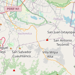


19.2028, -99.1183© OpenStreetMap
Anzeige · 300×250
Orte unter dieser PLZ
6| Ort | Region | Kreis | Koordinaten |
|---|---|---|---|
| Arboledas Zafiro | Distrito Federal | Iztapalapa | 19.2028, -99.1183 |
| Degollado | Distrito Federal | Iztapalapa | 19.2028, -99.1183 |
| La Magueyera | Distrito Federal | Iztapalapa | 19.2028, -99.1183 |
| Prados | Distrito Federal | Iztapalapa | 19.2028, -99.1183 |
| Predio San Rafael | Distrito Federal | Iztapalapa | 19.2028, -99.1183 |
| Tejocotes | Distrito Federal | Iztapalapa | 19.3491, -99.0569 |
Gleiche PLZ in anderen Ländern
2| Land | Ort | Region |
|---|---|---|
| UA Ukraine | Половецьке | Kyivska |
| US Vereinigte Staaten | APO AE | — |
FAQ
In welcher Stadt liegt 09704?
Arboledas Zafiro, Distrito Federal, Mexiko.
Welche Koordinaten hat 09704?
19.2028, -99.1183
Wird 09704 auch in anderen Ländern verwendet?
Ja, in 2 weiteren Ländern.
Aktualisiert am 2026-11-09. Quellenangabe in Daten & Lizenz.